5th RAC 2008 Road Atlas Britain 9.99
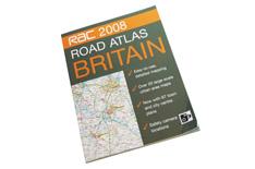
RAC 2008 Road Atlas Britain
RRP 9.99
Best of the web 8.66 at amazon.co.uk
Overall
Performance
This atlas has a glued spine, but its well-placed seam does away with spiral-bound atlases' problems of having a huge gap in the centre of the pages. The 1:200,000 scale in a near-A3 format balances practicality and detail reasonably well. Speed cameras are marked - but the speed limits aren't.
Ease of operation
The mapping is well laid out and the town maps well indexed. The maps of the UK's three major orbital motorways (M25, M42, M60) are useful. The plentiful town maps are sufficiently detailed to help out, even if they're not complete, while the close-ups of particularly dense urban areas add considerable detail.
Buying
The asking price is reasonable for an atlas of this quality and size, and the slight discount available by shopping around on the internet makes it a tempting deal.
Quality
This is a high-quality production, with laminated covers and thick, shiny paper that is unlikely to rip or bend except under severe provocation.
Special features
Overview maps, ferry information, restricted motorway junction details and motorway service locations are useful and well-indexed.